North Fork Washougal
W-1200 Road to Washougal River
Class: 4(5)
Length: 7 miles
Crafts: Kayaks
Season: Rainy
Boaters call this river the North Fork of the Washougal although some maps refer to it as the West Fork of the Washougal. Whatever you choose to call this river, the section from FR 1200 bridge to the main Washougal is one of the best Class 4 runs in Oregon and southern Washington. Classic scenery, spectacular geology, numerous classy Class 3-4 rapids, and a long season make the North Fork of the Washougal one of my absolute favorites.
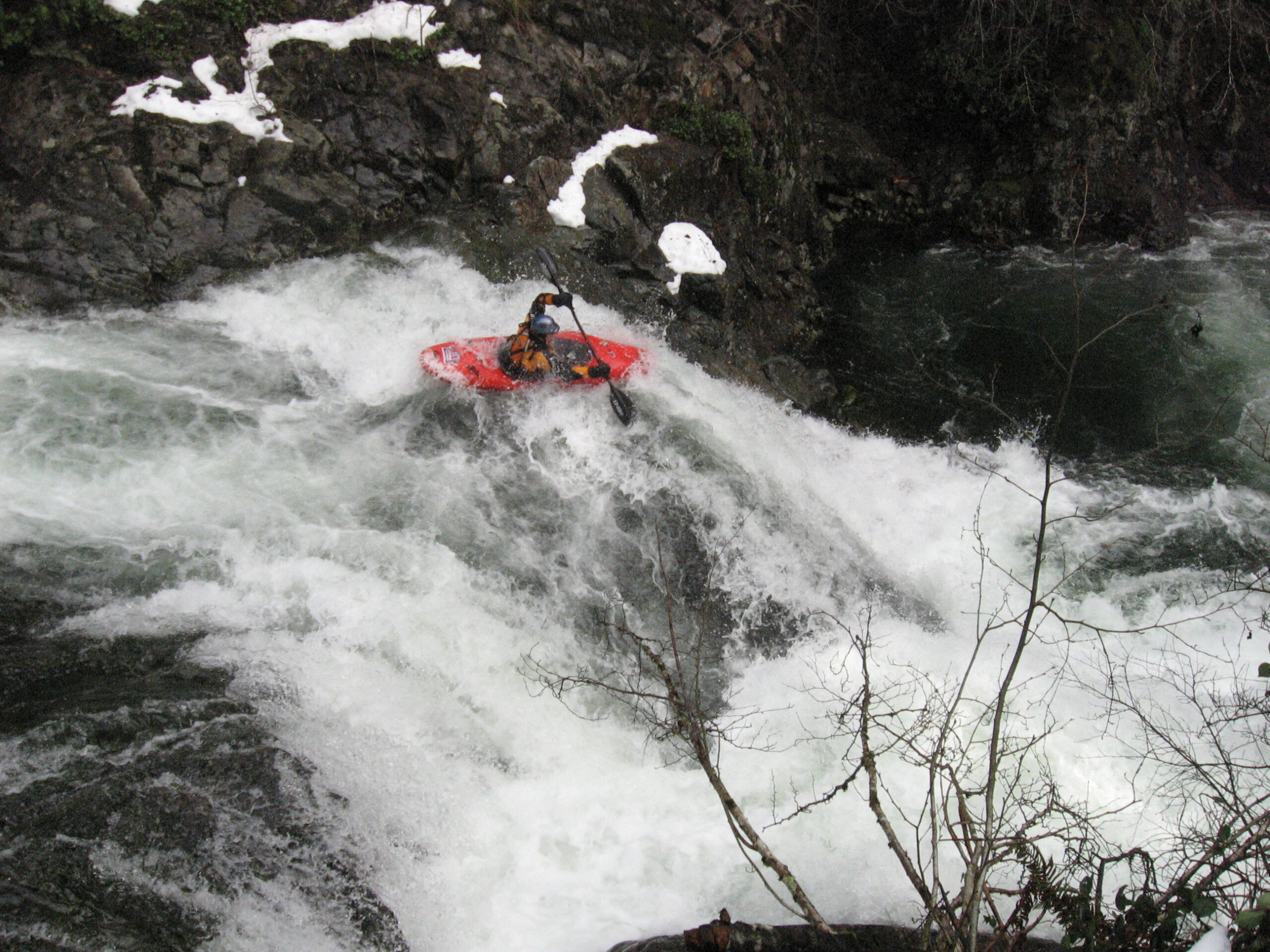
Jesse Drops into the 2nd Drop of Teakettle
River Description(Kayak/Raft)
From the uppermost put-in, the river starts out small, narrow and shallow. Don't fret! Just around the corner the river consolidates and begins to bounce through some fun ledges and twisty turns. At high water this section really moves along and the currents are tricky in several places. After just over a half mile on the river, Hagen Creek enters on the right and the river drops to the left over Teakettle Falls. Be sure to catch an eddy at the mouth of Hagen Creek in order to scout Teakettle. Teakettle is a 2-part rapid with a shallow slide at the top and a 10-foot ledge at the bottom. The right side of the ledge drops onto a rock and the left side drops into a sticky hole. If boaters decide to portage Teakettle there is a faint trail on the right. Boaters can lower boats to the base of Teakettle or continue downstream to less steep access to the river.
Below Teakettle the river mellows to Class 3 for several bends. Watch out for a tricky, narrow ledge drop at the end of series of shallow slides. This drop tends to push boaters into the left wall so be ready! After this drop, be on the lookout for mist rising from the next big drop. There is a shallow eddy on the left close to the lip of this 20-foot falls. Be sure to catch the eddy. About 50% of boaters seem to run this big drop. The rest (like me!) portage on the left to a 10-foot seal-launch to the base of the rapid.
Once past the big falls, the Class 4 goodness begins in earnest. There are numerous fun rapids with fun boofs, neat ledges and soft holes. Once boaters pass under a road bridge, there is one rapid before the next commonly portaged rapid. Catch the eddy on the left at the lip of the drop just after a series of fast waves. This nasty ledge drops 10-feet into a boiling, narrow slot. I've heard this drop has been run but have never seen it personally. There is a fun seal-launch off the rocks on the left into the pool below the slot. Just around the next corner is a fun rapid with some big offset holes.
Fun rapids continue downstream including several fast rapids with big holes. Be sure to scout what you aren't sure of as some of these rapids have been known to have wood in bad places. After a quieter section with several houses on the banks, the pace picks up again with a 5-foot ledge hidden on a sharp right turn. There is an easy portage on the left which gets runnable when the water is high. Otherwise pick from the narrow slot on the left, boof/seal-launch in the middle, or narrow, powerful slot on the right. Once below this rapid take a second to appreciate the huge basalt wall towering over the rapid on the left.
From here the fast pace continues with several more fun rapids before things slow down near the Fish Hatchery. If you continue past the hatchery, be careful of the powerful weir at the far end of the hatchery and the big rapid just around the corner. Most boaters choose to run the rapid down a fun chute on the left to avoid the powerful center drop which has undercuts on both sides in the landing. From here the rapids gradually diminish all the way to the confluence with the main Washougal. Turn right and if you've got any energy left, there is a great playspot just downstream from the confluence. It's all flatwater from there to the take-out.
Hazards
Until you know the run, I'd recommend approaching all horizon lines with caution so that you don't inadvertently run something bad. Scout Teakettle on the right, the next big falls on the left, the nasty slot below the first bridge on the left. Scout the fish hatchery weir from the road above the hatchery before the run. The folks at the hatchery don't allow scouting this weir from their property. Be on the lookout for wood throughout the run.
How to get there
Take-out (GPS: 45.607475°, -122.231593°)
The lowest take-out is located where Canyon Cr. Rd. crosses the Washougal River next to the Washougal River Mercantile Store. From Washougal, follow Washougal River Road upstream about 8.5 miles to Canyon Creek Road. The Washougal River Merchantile Store is on the corner. Turn right on Canyon Creek Road and park on the shoulder on the right.
Alternate Take-Out:(GPS: 45.620992°, -122.217655°)
Many boaters choose to take out at the Skamania Fish Hatchery. To reach the hatchery, continue upstream on Washougal River Road past the Merchantile Store another .9 miles and turn left at the sign for the Fish Hatchery.
Put-in (GPS: 45.690767°, -122.239039°)
To reach the put-in from either take-out, return to Washougal River Road and turn north on Skye Road which is about .5 miles east of the Merchantile Store. Follow Skye Road about 3.8 miles and turn right on NE 412th Ave./Skamania Mines Road. Follow Skamania Mines Road down the hill to a bridge that crosses the river. Cross the bridge and continue uphill until you reach a junction with a stop sign. Turn left and then turn left again after a couple hundred yards. Continue down this road until the next bridge that crosses the river.
Gauge
Estimate from other gauges. There is currently an internet gauge on the main Washougal (Washougal River at Hathaway Park gauge) which can be used to approximate the level on the North Fork. Flow on the NF Washougal is about 20% of that on the main Washougal. The EF Lewis ( EF Lewis at Heisson gauge) can also be used to estimate flow on the NF. Flows in the 1500-2500 range are recommended.
There is now a stick gauge located where Skamania Mines Road crosses the NF. Anything below 10" is considered low, above 15" or so is high.
More Info
Check out Jason's description of this run.
And additional info on AW site here