Elk Lake Creek
Elk Lake to Collawash River
Class: 4+-5
Length: 7 miles
Crafts: Kayaks
Season: Snowmelt
The logistics of boating Elk Lake Creek in it's entirety is daunting to say the least. With a 2-hour one way shuttle, access generally blocked by snow the majority of the boating season, and miles away from the nearest road, Elk Lake Creek certainly doesn't give away anything for free. Despite these complications, after kayaking the lower 2 miles of Elk Lake Creek several years ago I was intrigued about what it would take to explore the rest of the river upstream. Several scouting missions over the course of 3 years revealed the potential to do a complete run if the timing was right. Finally a group of friends and I decided to attempt a top to bottom run of Elk Lake Creek in spring 2006. We found a small, steep creek with wonderful old growth forest, and several large waterfalls and slides. Although the trip took us 14 hours to complete, Elk Lake Creek is definitely a worthy addition to any exploratory boater's resume.
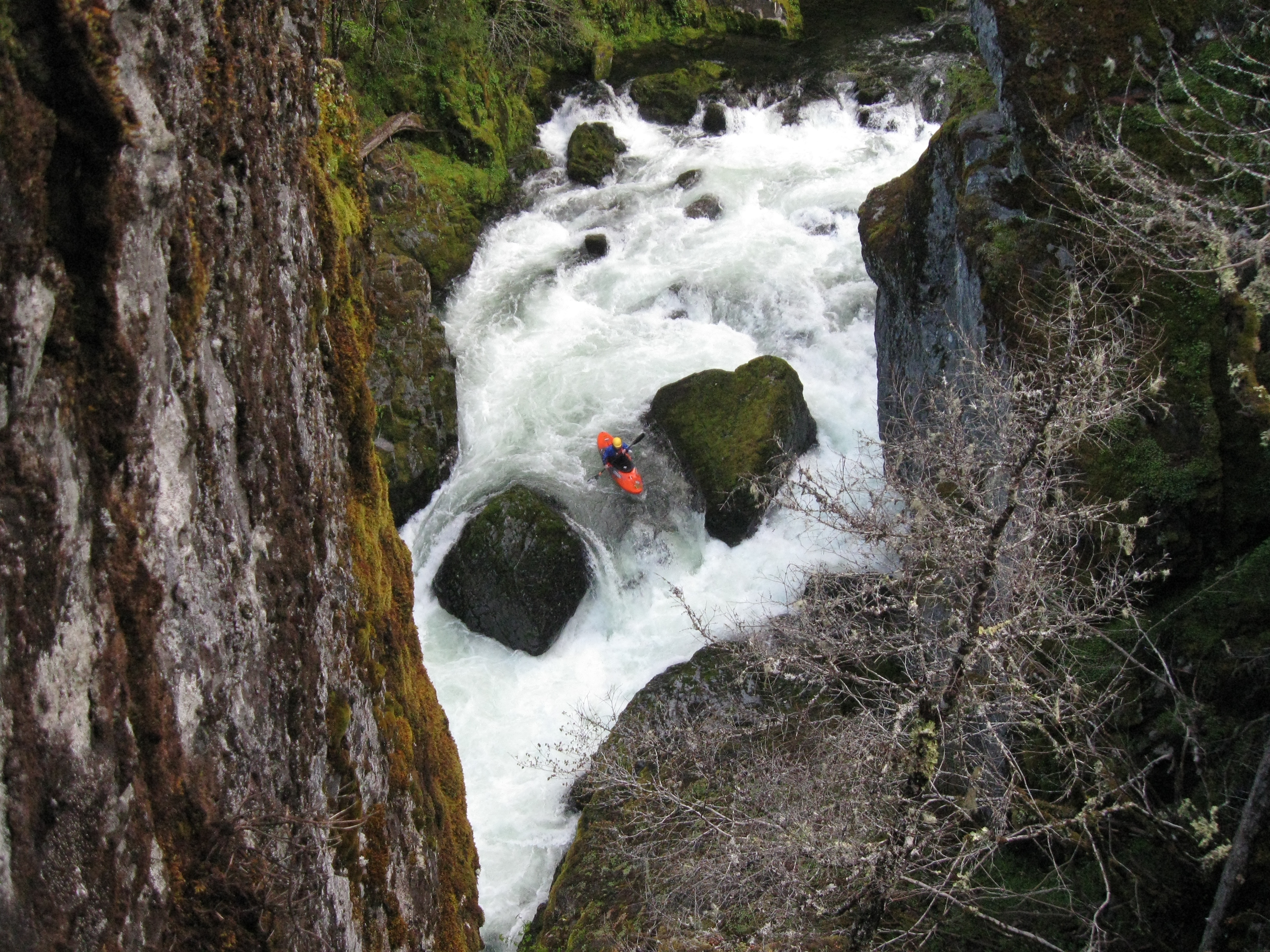
River Description(Kayak)
Elk Lake Creek flows out of Elk Lake through a swampy area and then begins a 9.5 mile descent through the Bull of the Woods Wilderness until it joins the Collawash River. After a mile or so, several tributaries contribute enough additional water to make floating a possibility. If you find the right put-in at a shallow section of the creek with lots of bedrock, you'll be treated to a wonderful 25-slide. Below this slide is several miles of small boulder gardens with the occasional steeper drop. We found lots of wood in this section but also a couple nice drops.
About 1 mile above the confluence with Battle Creek the boulders start to stack up and there are some nice drops separated by some mank. Be on the lookout for a big horizon line where it looks like the river narrows up. Eddy out quickly on the right to scout Little Demon. The first 15-foot slide pushes into the right wall. A very short pool separates this drop from the next 20-foot waterfall. Below this are two more fun ledge drops to complete the sequence. The whole thing can be portaged on the right with difficulty or you can put in above any of the drops to run some of them.
Below Little Demon are two more fun rapids; a 10-foot twisty slide and a 25-foot waterfall. The waterfall is best run on the right but be on the lookout for wood at the bottom. After the waterfall is one more short boulder garden before the creek completely flattens at the confluence with Battle Creek. The next 3-4 miles is scenic class 2 with a couple fun bigger drops scattered throughout until Elk Lake Creek begins it's final plunge down to the confluence with the Collawash. The final plunge begins with a fun 10-foot ledge which is best down the middle or on the right. A short pool leads to a beautiful 20-foot waterfall that has several exciting lines. After the waterfall, Elk Lake Creek enters a beautiful gorge with a big boulder garden around the next turn. Below the next pool the creek slides over a tricky 5-foot ledge and then drops 15 feet over a another ledge. This second ledge has had a lot of wood blocking the landing on the left but there is currently a clean line on the far right and on the right center. Scout carefully on the left before committing to the first ledge.
Below this the gorge continues for another half mile but there are only a few small rapids. Take the time to soak in the scenery and celebrate your accomplishment!
Hazards
The upper section above Battle Creek is small with a lot of wood. Scout carefully before committing to any drops. Scout the lower gorge by hiking up the trail from the take-out or from the river.
View Elk Lake Creek in a larger map
How to get there
Take-out (GPS: 45° 5'1.81"N, 122°29'19.83"W)
From the small town of Estacada, take Hwy. 224 about 23 miles upstream to Ripplebrook Ranger Station. Stay on the main road which bends to the right after the old ranger station and turns into FS 46. Continue to FS 63 and turn right on FS 63. To reach the put-in, continue on FS 63 about 14 miles to the bridge over the Collawash; staying right at major intersections after 8.25, 9.1 and 11.8 miles. The take-out is on the right under the bridge just downstream of the confluence with the EF Collawash River.
Put-in (GPS: 45° 5'12.99"N, 122°23'8.87"W)
There are two options to reach the put-in. First, continue on FS 63 another 1/4 past the bridge to the trailhead for Elk Lake Creek and hike about 8 miles to where you want to bushwack down to the river.
Second option, continue back on FS 63 all the way to FS 46, turn right and head all the way over the pass to the Breitenbush River. Follow the Breitenbush road downstream until you cross Humbug Cr. Turn right after Humbug Creek and follow the signs to Elk Lake. Figure out a way to bushwack down to the river and you're off! Needless to say, do some map work before you attempt this one.
Gauge
Visual. Look at the flow at the take-out bridge and try to guesstimate what is upstream. The Clackamas flow is a decent starting point. I'd think you'd want 2500+ and steady or rising for adequate flow.
More Info
Check out Jason's description of this run.